
Sorry about the abrupt end to my last post! My daily allocation of data while in Canada abruptly ended without warning, and with it my post! I try to use local WIFI rather than the terrible service that Verizon provides, but local WIFI isn’t always available in some of these small and remote harbors.
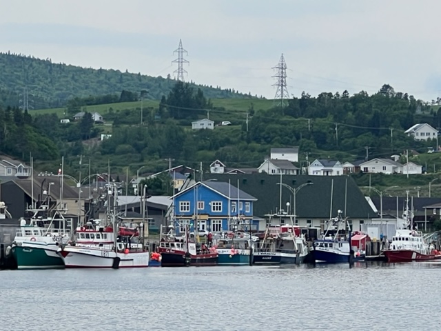
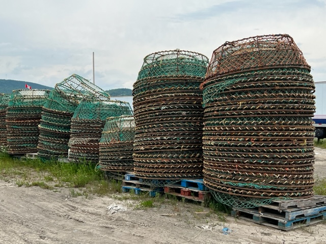
Our next stop after St. Anne des Mont was a large (by local standards) commercial fishing center on the Gaspe Penninsula called Riviere au Renard. With strong winds predicted later in the morning, we left at 5:45 AM to beat the forecast. Here are some images from Riviere au Renard:

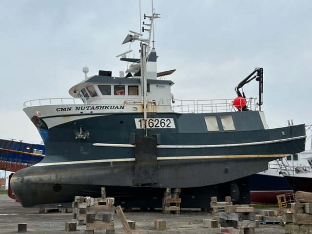
Fishing boats of all types were stored on land as well, some derelict and seemingly beyond repair, others which appeared seaworthy. Here are a couple of odd-looking vessels:

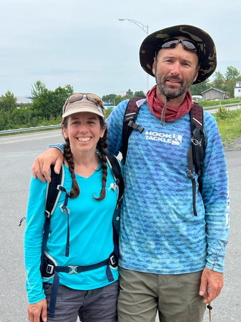
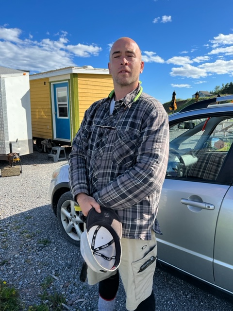
I stopped to talk with the fishermen who were loading ice via a conveyor belt (the grey tube in the picture), getting ready for the next outing. The son, Dave, is 36 and his Dad is 66:

Like Dave’s grandfather, both these men started fishing while in grade school, and it’s the only life they know. They fish for shrimp, although Dave told me that the shrimp catch is down by half over the last few years. They go out for trips that last about six days, in which they spend $40,000 on fuel alone! The boat is 16 years old, and cost $2.3 million new at that time. The same boat, Dave said, would cost $6.5 million today. While the shrimp catch has declined, Dave explained to me, the sea bass population has soared; however, there is little market for sea bass, so they throw them back.
As I rode my bike around the waterfront, I stopped at one of the two fish processing plants in town. I got off the bike and peered into a large window to see what it looked like inside. In another demonstration of the incredible outgoing friendliness and generosity of the people who live up here, a door in the plant opened as I was getting back onto my bike. The man in the door gestured for me to come in. Although he spoke not a word of English (nor me of French), he showed me around his area of the plant:

As Jim and I rode our bikes around town looking for the grocery store, we met Martini and another Dave, who were on a year-long sailing trip on a small, 26-foot sailboat anchored nearby. They instantly recognized us as boat people and vice versa (perhaps something about how we all dress, or the confused look in our eyes as we wander around town….). We chatted for awhile, admiring their spirit and enthusiasm as they pursued their dream adventure!
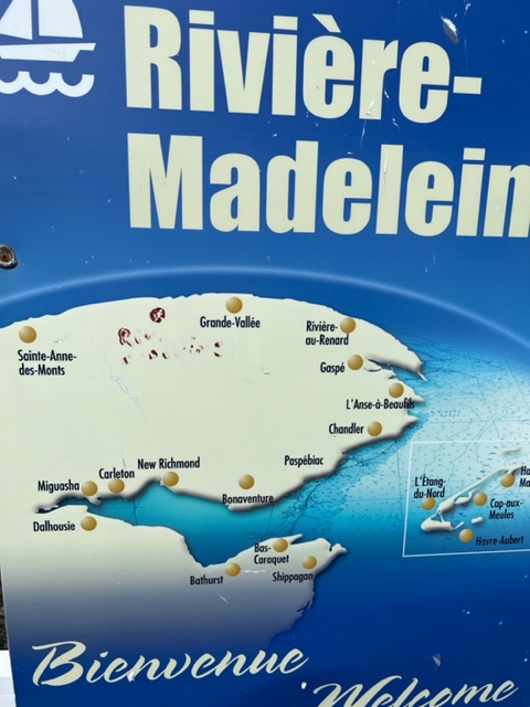
The Gaspe Penninsula, the land mass shown below, lies between the south shore of the St. Lawrence River and Chaleur Bay in coastal Quebec. The map below might help to visualize the geography and the location of some of the harbors that we have recently visited. On the upper left of the map below is Sainte Anne des Monts. Not shown (because it is tiny!) is the small harbor Riviere de Madeleine, where I went fishing with my new friend Dan – it is located about halfway between Sainte Anne des Mont and Riviere Renard, shown near the northeastern end of the Penninsula. Our next stop after Riviere au Renard was L’Anse-A’-Beaufils, where the Joint Adventure is now tucked in – at the outer tip of the Gaspe Penninsula on the map below. When we leave L’Anse-A-Beaufils, we’ll cross the wide Chaleur Bay to Shippagan, another commercial fishing port which is shown on the bottom of the map below. Chaleur Bay actually forms the southern boundary of the Province of Quebec, so upon crossing the bay to Shippegan, we’ll be entering English-speaking New Brunswick! We’ll also be entering the Atlantic time zone, so we’ll need to set our clocks ahead by an hour.
The Gaspe Penninsula is remote and rural, and much of it contains untracked wilderness. The coastline is spectacular, as you’ve seen in many of the pictures from Rimouski on, alternating between low mountains, steep cliffs, and sparse small coastal villages sandwiched between the mighty river and the steep mountain slopes. The villages are linear, with the settlements strung out, sometimes for miles, along one or two roadways which hug the river and run parallel to it. An occasional small farm is sandwiched between the river and the mountains where a small, sloped plateau provides barely enough space for a few small fields and a small barn.
The name “Gaspe” comes from the native word “gespe’g”, which means “end”. The Gaspe Penninsula is actually the northern terminus of the Appalachian Mountain chain, which stretches there from its southern terminus in Alabama.
Our Down East Loop plan has always included a six day respite in which we tie the Joint Adventure to a dock and travel to Killington, Vermont for our annual “Friends and Family Reunion”, otherwise known as “Mecca Mash”. Our plan was to leave the boat at a marina in the city of Gaspe, the largest city on the Gaspe Penninsula. However, when Gaspe Marina informed us that they wouldn’t tie up dock space for more than a day or two, we skipped the city of Gaspe and headed for the small harbor at L’Anse Beaufils. This was an exciting milestone run for us, as we were leaving the St. Lawrence River where we had spent the past four weeks, and in doing so, we were entering the expanse of the North Atlantic! However, it turned out to be even more exhilarating than we anticipated!
We again left at about 5:30 AM, anticipating increasing winds. However, this time they never really materialized.
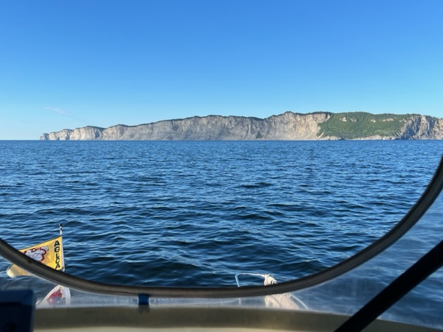
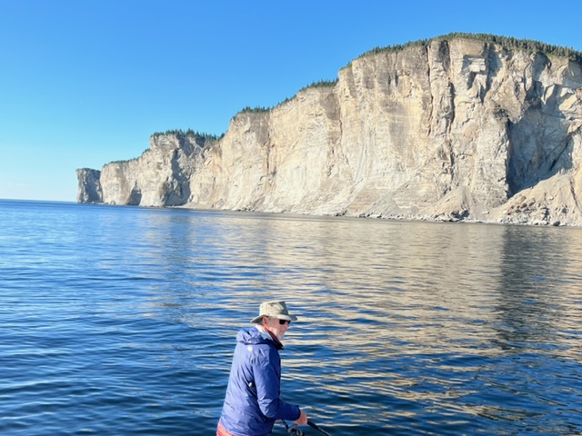
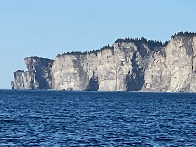
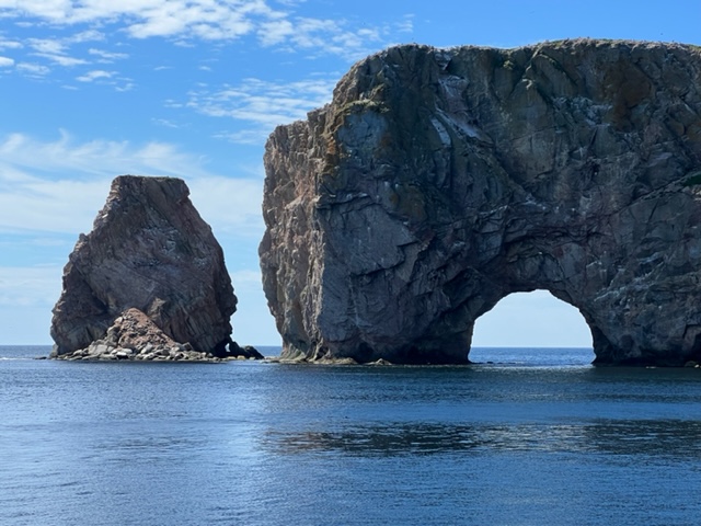
The southern mouth of the St. Lawrence punctuated the scenery we had been seeing along the way in spectacular form. The chart shows a spit of land sticking out into the sea as if the river just didn’t want to give way to the ocean. In viewing the chart, I assumed it would be a low-lying spit of sediment deposited over untold millennia. Instead, we found this:

As we rounded the corner to head south into the North Atlantic, two lighthouses came into view, guiding mariners from the open ocean into the mouth of the river for centuries


As if that wasn’t enough excitement for the day, about a half hour into our foray into the North Atlantic, we spotted the spouting of whales. We slowly headed in the direction of the whales, which seemed to be a pod of three or four large specimens. I don’t know what species they were, and my attempts at photographs fell woefully short:


A number of seals were hanging around as well, and seemed more fascinated by us than we were of the whales:

As we watched the whales periodically surface then slip below the surface, I asked Paul and Jim if they had ever seen a whale breach. Neither had, nor had I. Incredibly, 30 seconds later, a whale shot near vertical from the mirror-like surface of ocean, then crashed into the water with a monstrous splash! We were mesmerized!
As if that wasn’t enough excitement for the day, when we rounded the next headland, we were greeted by this sight:


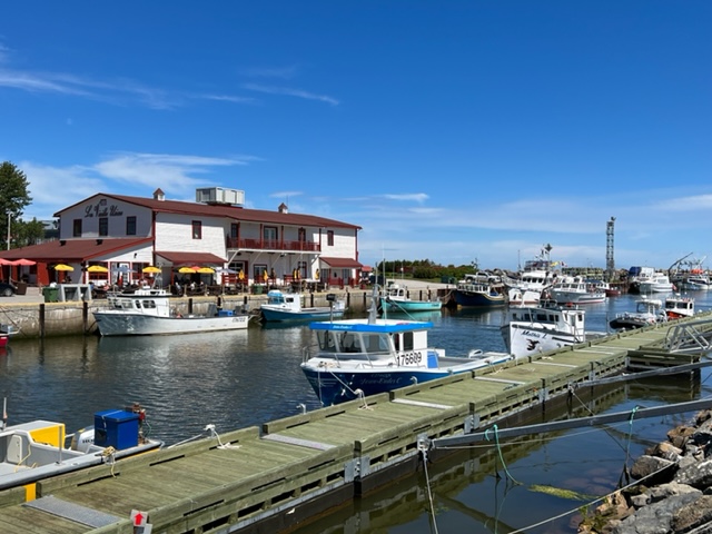
After lingering around Perce Rock, we motored to our destination of L’Anse Beaufils, a small fishing harbor about 6 nautical miles beyond Perce Rock. There we met Nicholas, who manages the harbor and speaks fluent English!! He proved to be a gem – outgoing and friendly, always willing to help us out in any way he could! He also knows more about US politics that most Americans, and we’ve had some very interesting political discussions!
Nicholas managed to squeeze the Joint Adventure into the small harbor for our extended stay. It was coincidental that there is a brewery with a wide selection of IPA’s, lagers, ales, and even sours located on shore right by the boat! Here are a couple of images from the harbor:

A couple of miles off the coast of Perce is Ile-Bonaventure, a 2 1/4 square mile island that was designated as a Canadian National Park in 1985:

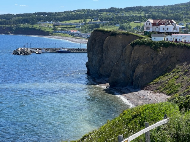
Perce Village, adjacent to Perce Rock, is about 8 miles by car from the harbor at L’Anse Beaufils. Since there are no taxis or Uber in the area, Nicholas was kind enough to drive us to Perce Village, a tourist town next to Perce Rock with plenty of restaurants, pubs, and a variety of shops, and which serves as a jumping up spot to visit Ile Bonaventure. Here is a view overlooking a portion of Perce Village:
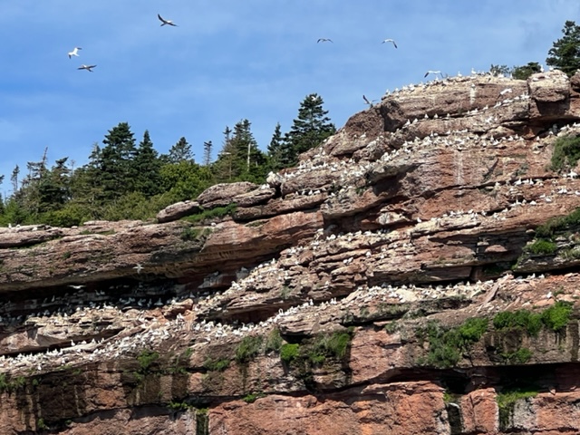
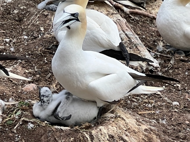
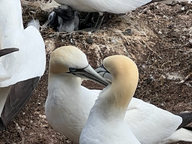
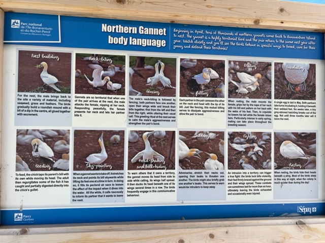
In the first part of the 1800’s, Ile Bonaventure was an early seasonal fishing port of New France, and later in the 1800’s became the second largest cod fishing center in Quebec. A portion of the island was inhabited by workers at the cod fishing operation, and later by 35 families who made the island their home. Another portion of the island is home to hundreds of thousands of migratory birds, dominated by the northern gannet. As a result, in 1971, Quebec acquired ownership of the entire island, purchasing all of the existing homes by eminent domain and evicting all of the residents, then opening the entire island as a park accessible to the public. Today, it is one of the largest bird sanctuaries in the world, and is home to nearly 300,000 birds, including one of the two largest gatherings of northern gannets in the world. It is an amazing sight to see, as the hiking trails on the island bring you “up close and personal” with the gannet population, as you’ll see!
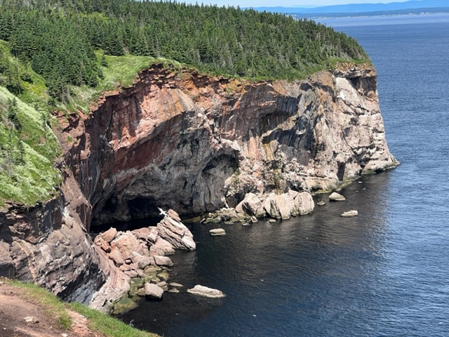
We boarded a tour boat that first took us on a tour around the perimeter of the island; here are some images of the amazing island coastline:

There was other wildlife along the island coastline as well:


After touring the perimeter of the island, the tour boat docked and the passengers debarked to hike the various trails that crisscross the island. We chose the 6 mile trail that mostly hugged the coastline:


Travel around and from the island was a challenge:

We’re now in Killington, Vermont to attend the annual summer party that I mentioned above – a tradition started in 1974, and a celebration that is now attended by members of the third generation! Paul, Jim, and I boarded a flight from Gaspe Airport which flew us to Montreal, where we rented a car and drove 4 1/2 hours to Killington. The Joint Adventure is tucked in in L’Anse Beaufils, where we’ll return to resume our journey in a few days.
In the meantime, a final story about the St. Lawrence River as we leave it behind: As you might imagine, there have been countless shipwrecks on the St. Lawrence over the past centuries since Europeans arrived in the 1500’s. The most famous and by far the deadliest was the collision of the passenger ocean liner “Empress of Ireland” with the Norwegian freighter “Storstad” in 1914. The bow of the Storstad plowed head-on into the side of the Empress in thick fog, causing the entire Empress to disappear beneath the waves within 14 minutes! Of the 1,477 people aboard, 1,012 perished. However, an Irishman named William Clark was one of the 465 survivors. What was noteworthy about William Clark? In 1912, he was aboard the Titanic when it struck an iceberg and sank in the North Atlantic – which he survived as well. A lucky man indeed! Even more extraordinary, if it’s true, is the story of Francis Tuohy, who was born in 1863 in Hyde Park, Massachusetts. According to newspaper reports at the time, Tuohy was tending the engines of the Titanic when it struck the iceberg and sank, but Tuohy managed to escape and survive. Two years later, in 1914, he was a crew member aboard the Empress of Ireland when she was rammed and sank in heavy fog in the St. Lawrence. If news accounts at the time are correct, Tuohy was then aboard the Lusitania in May of 1915 when it was struck by a torpedo from a German boat – and again, he survived. However, the news accounts at the time were never verified, so there is some question whether this account is accurate. In any case, I would think twice about letting him aboard my boat!!
We have now traveled 1247 nautical miles, or 1435 statute miles, which is a bit less than half of the total distance for the trip. However, we anticipate that the second half of the trip will take a bit longer, in part because we have built in about 9 days for sightseeing in Prince Edward Island and Nova Scotia, and in part because we have built in more weather days due to our now being in the open ocean for most of the rest of the trip and our expectation of increased fog and wind.
More to come!!

Leave a comment